Assignment 6 – Mapping it out – #edtechcca6

Make a custom map using Google Maps.

Use Google Maps to create your own custom map that includes photographs of places.

I’ve been playing with google maps and the google maps api for a while so was please t osee some familiar territory for this Assignment.

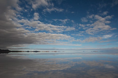
This afternoon Dorothy, my wife, and I took a walk round Ardinning Loch, we do this nearly every week often twice a week in the summer, It is a short walk that is always interesting. Ardinning is a SWT reserve.

I used Trails on my phone to record a kml and gps track. The kml file was imported int oa new google map. I uploaded the photos it was then just a matter of dropping on some pins, filling in a title and pasting in the url to the image file.


View Ardinning in a larger map

Another approach

Over the last few year I’ve played with developing a workflow for creating maps like this using the GoogleMaps API. For this I use SuperCard, a mac scripting application. The project allows me to import a gpx file exported from Trails, get exif data for some pictures, iPhone photos have location data imbedded (It also lets me add locations to other pictures by comparing the time taken with the gps file). It then exports a gpx file which I upload to this website and a php file created a map.

Here is the Ardinning Walk map 120303 Ardinning and a whole set of Mapped Walks. In my opinion this has a few advantages over using google maps, you can embed audio & video, and the popup boxes link in sequence. It is also a faster to produce. Obviously it has the disadvantage of being a wee bit trickier to set up.

I’ve a fair number of blog posts going into this in a bit more detail: tagged googlemaps.

But what is it good for?

I think these sort of maps add another dimension to telling a story or presenting information. helping to tell a story in space as well as time. I can see this being incorporated into all sorts of class room projects, either for mapping learning experiences or creating fictional maps. This one The Kidnapped Trail – Google Maps is a great example of the possibilities.

A little bit of DS106

It loks like I can kill two birds here: Google Maps Story — MISSION: DS106

The places I want to go for sure.

Assignment: Good Map Story
I would like to talk some place I want to go in the future.
Salar de Uyuni
First of all, I will introduce Salar de Uyuni.

Salar de Uyuni is the world’s largest salt flat which is located in Blivia.
When it is covered with water, it becomes like a huge mirror.
?
Sorry, this video is in Japanese, but I selecetd this one because this has a so many amazing scene of Salar de Uyuni.
But, isn’t this fantastic??
Ths salt lake perfectly reflect the beautiful sky.
It is like you can hardly tell which side is heaven or earth!
Ths next place I would to tell is Jiuzhaigou Valley which was designated a UNESCO World Heritage Site in 1992.
CIMG0119
It is located in China.
The valley combines clear blue lake, waterfalls, beautiful mountains, and forests.
Especially, I want to see this clear blue lake which is called five-flower lake!
You can clearly see the bottom of the water.
The lake changes its colar at times. It sometimes turns to ink-green and yellow, but it stays diamond blue most of the time.
 
 
Lastly, I want to visit Yurigahama beach in Okinawa!
 
 
My hometown is the closest prefecture to Okinawa, but I have never been to this beach.
This small beach only appears when the tide is low.
The sand on this beach is shaped like a star.
According to legend, the more you can collect the sand, the more happy you get.
 
There are more places I want to visit, but it would take forever to introduce all the places.
Through this blog, I realized that I love clear and blue water.

ds106 Web Assignments 105 "Google Maps Story"


View Larger Map

Soooooooo here is where I am from, it is Iran, Tehran (the capital city of Iran) in Ariashahr. This is where I used to live and where my home is. There are a lot of historical places in Iran including  Perspolis which was built more than 2000years ago. Also Iran is where Persian Carpets, Persian Cats, Sheesha, Pistachio come from. Also we have four season! So we have WINTER! hahahaha. Most people have the HOT weather image of middle eastern countries but it is actually colder than Japan in winter. We have one of the biggest Ski Pist which is world’s 4th biggest mountain around Tehran, so I used to go to ski every weekend. It only takes one hour to go there and it is very cheap as well. This is why a lot of foreigners come to Tehran during winter time to ski! It costs approximately 2000yen per day, including renting everything and the entrance! You are more than welcome! 

Assignment Description  

de106 #3 I have been in here! (by using google map)

First of all, here is my hometown. I was born in Tokyo, and during elementary school, I lived Fukuyama city with my family. Fukuyama city locates in Hiroshima Prefecture, and second-largest city in Hiroshima Prefecture.


Secondary, when I was in junior high school and high school, I was in dorm which is at Matsuyama city in Ehime prefecture.


This city has many spas like “Dougo-Onsen.” and known as the origin of “Haiku.”

and then, I moved to Tokyo!

I love these cities, and maybe the end of next year, I will move to California!! 

Google Maps Story

For this assignment, I chose Sapporo (capital of Hokkaido, which is the northernmost island of Japan) because I went there with my high school teachers and friends before graduation. We saw Sapporo City. It was very beautiful and different from Tokyo. The roads were broad and there was plenty of greenery. Sapporo is renowned for the Shiroi Koibito chocolate brand. Here is the map.


View Larger Map

The idea for this type of interesting assignment was submitted by David, who is also known as Mr. Thimble.

Following are the steps I used to embed the Google map.

1) I searched Sapporo Google map.

2) I clicked on the Link button (which is after the Get Directions, My Places, and is to the right-side of Print button) in the left-side panel. 

3) Then, I copied the HTML code to be embedded and pasted that code in the Edit HTML tab of the blog.

4) After pasting, I just clicked on the Compose tab.